A Trimble S7 total station set up on the eastern side of a Pukekohe basement excavation picks up 12 monitoring prisms every 30 minutes—day and night, through winter squalls and summer dry spells. The instrument tracks movement on the battered cut face, the adjacent road reserve, and the shoring walers, logging three-dimensional displacement to sub-millimetre precision. Our field crew installs the targets, calibrates the control network against stable benchmarks beyond the zone of influence, and configures automated alerts tied to trigger values derived from the geotechnical model. In the volcanic-derived soils that mantle much of Pukekohe’s low-rolling terrain, surface movement can precede deeper failure by hours; the job of the monitoring array is to catch that signal before it becomes a safety incident. This work sits at the intersection of surveying, geotechnics, and construction sequencing, and it demands instruments that hold zero under thermal drift and operators who understand what the numbers mean when the trend line starts to climb. A well-instrumented excavation also provides the baseline data needed for a defensible slope stability analysis if conditions change mid-project.
An inclinometer casing that shows 2 mm of cumulative deflection at 6 metres depth tells you more about excavation stability than a hundred visual inspections ever will.
Local considerations
Pukekohe sits on a patchwork of weathered basalt, tuff, and alluvial silts deposited by the ancient Waikato River system. This geological mosaic means two excavations 200 metres apart can behave completely differently—one stable in near-vertical cuts, the other slumping at 1:2. The climate adds another layer: Franklin’s winter delivers 120–140 mm of rainfall per month, saturating the upper colluvium and reducing soil suction to zero. A monitoring programme that only tracks displacement can miss the precursor—pore-water pressure buildup—that turns a routine cut into a stability failure. Our team installs vibrating-wire piezometers in boreholes behind the excavation face, logging pressure heads in real time and correlating them with inclinometer deflection. When the pressure rises and the deflection curve steepens in the same 24-hour window, the site team gets an amber alert and the engineer can order a temporary reduction in cut depth or additional dewatering before the morning shift arrives. Vibration monitoring is equally critical when the excavation is near Pukekohe’s light-industrial zones, where continuous operations cannot tolerate unscheduled downtime from construction-induced ground movement. A single exceedance of the peak particle velocity threshold can halt work, trigger insurance claims, and sour the relationship between contractor and neighbouring business—all avoidable with properly configured geophones and a monitoring technician who understands the site-specific response spectrum.
Frequently asked questions
When is geotechnical monitoring mandatory for an excavation in Pukekohe?
Under NZS 3910 and the Health and Safety at Work Act 2015, monitoring is required whenever an excavation exceeds 1.5 metres depth and is adjacent to public assets, neighbouring structures, or buried services. The Pukekohe area has additional trigger points when work encroaches on the railway corridor or when the excavation cuts through the Puketoka Formation’s sensitive clay layers. The design engineer specifies the monitoring plan as part of the construction documentation.
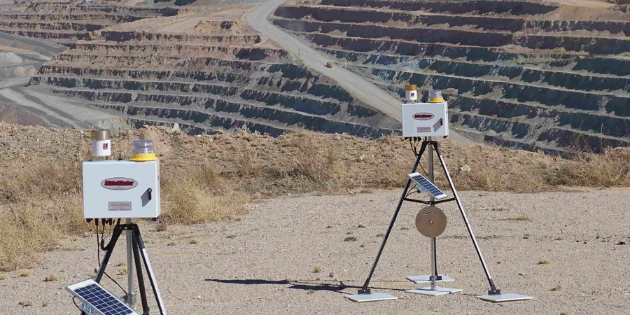
What instruments do you typically install for a basement excavation monitoring job?
A typical Pukekohe basement monitoring setup includes two to four inclinometer casings behind the shoring, surface settlement points on the adjacent road and footpath, crack monitors on any pre-existing buildings within the zone of influence, and a total station for automated prism tracking. If the excavation is deeper than 3 metres or within 50 metres of sensitive receivers, we add tri-axial geophones for vibration monitoring and vibrating-wire piezometers for pore-water pressure tracking.
What does excavation monitoring cost for a Franklin construction project?
Monitoring programmes in the Pukekohe area typically range from NZ$1,320 for a short-duration manual monitoring setup on a shallow trench to NZ$4,630 for a fully automated instrument array on a deep basement excavation with real-time reporting. The final cost depends on instrument count, reading frequency, duration, and whether automated alerts or manual reporting is required.
How quickly can you mobilise if we detect unexpected movement on site?
For existing clients with active monitoring programmes, we can have a senior technician on site in Pukekohe within two hours to verify readings, check instrument calibration, and install additional monitoring points if the zone of influence has expanded. For new clients, we can deploy a rapid-response monitoring kit within 24 hours, starting with surface settlement points and manual inclinometer readings while the automated system is being configured.