Pukekohe’s expansion from a small rural service town into a northern Waikato growth hub has placed new demands on its underlying ground. The Franklin District basalt that gave the region its rich volcanic soils also creates highly variable subsurface conditions, where weathered rock, clay pockets, and alluvial silts can sit within metres of each other. Standard borehole logs often miss these transitions, which is why the Cone Penetration Test (CPT) has become the preferred investigation tool for engineers working across Pukekohe. Instead of retrieving disturbed samples at fixed intervals, a CPT rig pushes an instrumented cone continuously into the ground, recording tip resistance, sleeve friction, and — with CPTu — pore water pressure in real time. The result is a near-continuous geotechnical log that captures thin soft layers, drainage boundaries, and the depth to competent bearing strata with a resolution no other method can match. When the data is paired with a triaxial testing programme on selected samples, the engineer obtains both strength parameters and a verified stratigraphic model for foundation design. For larger commercial sites near the town centre, where alluvial deposits of the Waikato River system overlie the basalt, integrating CPT with MASW geophysics provides a three-dimensional picture that reduces uncertainty in settlement predictions.
A single CPT sounding in Pukekohe’s volcanic terrain delivers more stratigraphic detail than three boreholes, resolving thin ash layers and drainage boundaries that control settlement rate and liquefaction susceptibility.
Methodology and scope
The humid subtropical climate of northern New Zealand, with Pukekohe receiving around 1,300 mm of rainfall annually, keeps the near-surface volcanic ash soils in a partially saturated state for much of the year. This moisture regime directly influences CPT interpretation, because partially saturated pumiceous silts can exhibit drained behaviour during penetration despite appearing fine-grained — a phenomenon well documented in North Island volcanic terrains. Our CPT equipment uses a 15 cm² or 10 cm² electronic cone with a 60-degree apex, pushed at the standard 20 mm/s rate specified in ASTM D5778, to generate three continuous channels: corrected cone resistance (qt), sleeve friction (fs), and dynamic pore pressure (u2). From these, the soil behaviour type index (Ic) is calculated using the normalised charts updated by Robertson in 2016, allowing classification without a single bag sample. When a project demands stiffness profiles at depth, we deploy a seismic cone (SCPT) with a triaxial geophone spaced at 1-metre intervals to capture shear wave velocity (Vs) during pauses in penetration. This same Vs profile feeds directly into NZS 1170.5 site classification and, when correlated with
liquefaction triggering analysis, identifies layers susceptible to cyclic softening under the design earthquake. In the deeper alluvial channels south of Pukekohe, where the CPT can reach 25 to 30 metres before encountering basalt refusal, the pore pressure dissipation tests provide in situ consolidation coefficients that reduce the need for lengthy laboratory oedometer campaigns.
Local considerations
The weathered basalt residuum underlying much of Pukekohe presents a specific CPT challenge: the transition from stiff residual clay to highly fractured rock can occur over less than 50 centimetres. A cone that is still recording clay-like friction ratios at 15 metres may refuse abruptly when the tip encounters a corestone or unweathered basalt float. This refusal risk is managed by monitoring the penetration resistance trend and stopping the push when qt exceeds 50 MPa, rather than risking cone damage that compromises data from subsequent soundings. A separate but equally serious risk is misinterpreting a partially drained silt as a clay — the Robertson chart alone cannot distinguish drained from undrained behaviour in intermediate soils. The correction is made by examining the pore pressure parameter Bq: if Bq is low while the soil behaviour type plots in the clay region, the material is likely draining during penetration, and its consolidation characteristics must be evaluated through dissipation tests rather than assumed from classification. In the low-lying areas east of Pukekohe, where the water table sits within 1.5 metres of the surface during winter, undrained penetration in saturated pumice sands can generate excess pore pressures that temporarily reduce the measured cone resistance by 10–15 percent. The corrected qt profile, accounting for this pore pressure effect, is the only reliable input for shallow footing bearing capacity calculations under NZS 3604 or AS/NZS 1170-based structural loads.
Frequently asked questions
What does a CPT cost for a residential site in Pukekohe?
A single CPTu sounding to 10–15 metres depth on a standard residential section in Pukekohe typically ranges from NZ$250 to NZ$450, depending on access conditions, the number of dissipation tests required, and whether the basalt is encountered at shallow depth. Mobilisation costs are reduced when multiple soundings are scheduled on the same day, which is common for larger lots or subdivision work.
How deep can a CPT rig penetrate in the volcanic soils around Pukekohe?
In the alluvial and volcanic ash deposits that dominate the Pukekohe basin, penetration depths of 20 to 30 metres are routinely achievable with a 20-tonne push system. The limiting factor is the underlying basalt: when the cone tip encounters unweathered rock or large corestones, qt rises sharply and the push is stopped at refusal — typically between 15 and 25 metres in the hillier parts of town. The refusal depth itself is valuable data, marking the top of competent bearing material.
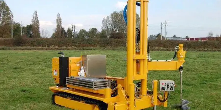
Can you do a CPT without a drill rig, and how does it compare to boreholes?
Yes, CPT is a self-contained push test that requires no drilling fluid, no cuttings disposal, and no separate sampling — the instrumented cone is pushed directly from a truck-mounted hydraulic ram. Compared to conventional boreholes with SPT sampling, a CPT log is continuous rather than at 1.5-metre intervals, so it captures thin layers that would be missed entirely by split-spoon recovery. The trade-off is that no physical sample is retrieved; when soil index testing is needed for classification confirmation, the CPT data guides selective sampling from a complementary test pit programme or targeted borehole.