Drive from the basalt-rich hills around Pukekohe Hill down toward the low-lying market garden flats along Manukau Road, and the ground beneath your wheels changes completely. Up high you are sitting on weathered volcanic rock that transmits seismic waves one way; down on the valley floor the deep alluvial silts and peats of the former swamp plain amplify motion in a markedly different manner. This contrast matters because Pukekohe sits in a moderate seismicity zone where a magnitude 6+ event on the Kerepehi Fault or a distant subduction interface rupture can shake different neighbourhoods with very different intensities. A seismic microzonation study maps those differences block by block, giving structural engineers the site-specific spectral accelerations and site classes they need to design foundations that actually match the ground under the building. When the shallow basalt gives way to compressible organic soils within a single subdivision, we often run complementary MASW surveys to capture the shear-wave velocity profile across the transition, ensuring the ground model captures both the stiff and the soft side of the site.
Two buildings 300 metres apart in Pukekohe can see a 40% difference in spectral acceleration at 0.3 seconds, purely because one sits on basalt and the other on 12 metres of alluvium.
Local considerations
A five-storey mixed-use building proposed on former market garden land off Kitchener Road showed us how quickly the risk picture shifts when microzonation is skipped. The preliminary structural design assumed Site Class C and a base shear that looked comfortable on paper. Core samples pulled up three metres of fibrous peat over soft silty clay extending to eight metres depth, sitting on a buried basalt flow that drops away sharply on the east side of the site. The Vs30 profile placed the eastern half of the footprint in Site Class D, triggering a 35% increase in design spectral acceleration at the building’s fundamental period. Had the microzonation not been performed, the lateral load-resisting system would have been under-designed and the pile lengths would have missed the basalt anchorage on the deeper side. In Pukekohe’s volcanic landscape, where paleo-valleys filled with compressible sediment hide under a flat ground surface, seismic microzonation is not a box-ticking exercise. It often reveals a basin-edge effect that amplifies long-period motion well beyond what a desktop site class estimate would predict.
Frequently asked questions
How much does a seismic microzonation study cost for a typical Pukekohe development site?
For a standard commercial or multi-residential site in the Pukekohe area, the cost generally runs between NZ$6,680 and NZ$32,010 depending on the number of measurement points, the depth to rock, and whether 1D or 2D analysis is required. A small site with one MASW line and a single borehole sits at the lower end; a multi-hectare subdivision with several boreholes, crosshole testing, and full ground response modelling moves toward the upper range. We always provide a fixed-price proposal after reviewing the geomorphological setting and the structural engineer's required outputs.
When does Auckland Council require site-specific seismic microzonation instead of using the default site class?
The council's acceptance of a default site class depends on the importance level of the structure and the ground conditions. Under NZS 1170.5, a site-specific study is triggered when the soil profile does not clearly fit Class A, B, or C, or when the building is IL3 or IL4. In Pukekohe, where peat, soft alluvium, and variable basalt depth are common, the NZGS guidelines strongly recommend microzonation for any structure taller than two storeys or with an irregular lateral system, because the default class often underestimates spectral accelerations.
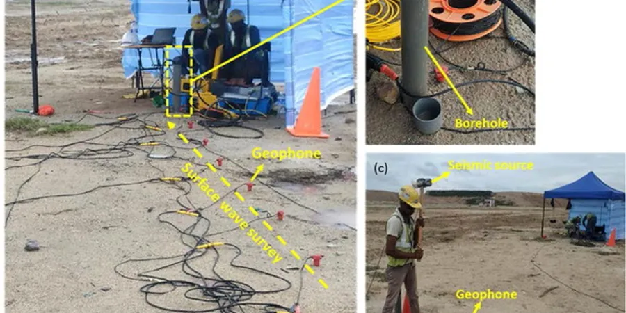
What geophysical methods do you use to measure Vs30 in Pukekohe's volcanic terrain?
We typically use a combination of active MASW (multichannel analysis of surface waves) with 24- or 48-geophone spreads for the upper 30 metres, supplemented by downhole seismic testing inside boreholes where we need higher resolution at specific depths. On noisy urban sites we add passive microtremor arrays and HVSR measurements to extend the dispersion curve to longer wavelengths. The volcanic ash layers and basalt flows in Pukekohe produce strong impedance contrasts that surface-wave methods capture well, but we always ground-truth the velocity model against borehole logs and SPT N-values.
How long does a seismic microzonation study take from field work to final report?
For a typical Pukekohe project covering 0.5 to 2 hectares, the field work takes two to five days depending on the number of seismic lines and boreholes. Laboratory testing of samples for dynamic properties adds two to three weeks. The site response modelling and reporting phase takes another two to three weeks. In total, you can expect the final microzonation report with GIS maps, site class polygons, and design response spectra within four to six weeks of receiving the purchase order, provided weather and drilling access allow continuous work.