The drill rig hits refusal at three metres, but the bedrock profile still needs to extend to 30. We see this pattern across Pukekohe—the Bombay Basalt and underlying Waitemata Group sediments create sharp velocity contrasts that standard penetration tests cannot resolve alone. Seismic tomography fills the gap. The method reconstructs a continuous velocity cross-section between boreholes or along a survey line, distinguishing fresh basalt from highly weathered tuff, and mapping the paleo-surface where East Coast Bays Formation sandstone dips beneath volcanic overburden. With a 48-channel Geometrics Geode system and 4.5 Hz geophones, the crew can acquire a 115 m spread in under an hour on prepared ground, then process the first-arrival picks through iterative damped least-squares inversion. The resulting P-wave velocity model typically resolves layers to ±0.5 m vertically across the top 20 m, which is sufficient for foundation depth decisions and cut-fill balance estimates on the undulating terrain south of the Manukau Lowlands.
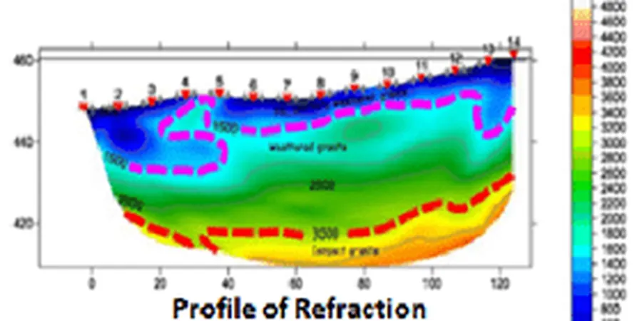
A 115 m refraction spread with 5 m geophone spacing resolves basalt depth to ±0.5 m across the top 20 m of the Pukekohe volcanic sequence.
Local considerations
The Pukekohe volcanic field is young—eruptions occurred as recently as the Pleistocene—and the basalt flows are notoriously discontinuous. A single borehole may encounter solid basalt while a second hole 15 m away finds only ash and lapilli tuff. Relying on point data alone leads to over-excavation or, worse, placing a footing on a boulder mistaken for bedrock. Refraction tomography maps the continuous velocity interface, reducing the risk of misinterpreting floaters as the true basalt surface. In the southern part of town, where the basalt thins over Tertiary sandstone, perched water tables form after heavy winter rain; the saturated ash layer can attenuate P-waves by more than 40%, so we adjust the gain window and stack count dynamically in the field. For sites near the Pukekohe East explosion crater, reflection profiling is preferred because the inward-dipping tuff beds produce velocity inversions that refraction cannot image. The combined approach—refraction for the overburden-bedrock contact, reflection for internal stratigraphy—gives the geotechnical engineer a defendable ground model for NZS 3404 compliant foundation design.
Frequently asked questions
How deep can seismic refraction reach in Pukekohe basalt terrain?
With a 115 m spread and sledgehammer source, we typically image to 25–30 m depth. The limiting factor is the seismic velocity of the basalt itself—once the head wave travels through competent basalt (Vp > 4000 m/s), deeper refracted arrivals from the underlying sandstone become difficult to distinguish. For targets deeper than 40 m, we recommend supplementing with a reflection survey or a borehole with downhole seismic logging.
Can you survey paved areas or sites with heavy truck traffic?
Yes, with adjustments. On asphalt or concrete, we epoxy-mount the geophones directly to the surface and use a smaller 4 kg hammer to reduce surface-wave noise. For sites adjacent to active roads, we schedule acquisitions during off-peak hours—typically early morning in Pukekohe—and apply a 60 Hz notch filter to suppress mains hum and vehicle-generated low-frequency rumble.
What is the cost range for seismic tomography in Pukekohe?
Surveys fall between NZ$5,120 and NZ$8,940 depending on spread length, number of shot points, and whether reflection or MASW is combined with the refraction acquisition. A standard 115 m refraction line with five shot points sits near the lower end; adding a parallel MASW array or a reflection segment moves the quote toward the upper end.
How does seismic tomography compare with CPT or SPT for ground class determination?
CPT and SPT measure strength at a point; seismic tomography measures stiffness over a continuous profile. Under NZS 4203, site class is based on shear-wave velocity (Vs30), which seismic methods directly measure. A combined program—one CPT or SPT borehole calibrated against a refraction line—gives both strength and stiffness, and is the approach we recommend for Pukekohe sites with highly variable volcanic stratigraphy.
What surface conditions prevent a successful survey?
Loose dry sand, thick mulch, or freshly ploughed soil absorbs high-frequency energy and degrades the first-arrival pick quality. In these cases, we pre-compact the geophone stations with a hand tamper or, for larger areas, request a light roller pass. Standing water is not a problem for the geophones—they are rated IP67—but the hammer plate needs to be kept dry to maintain a consistent source signature.